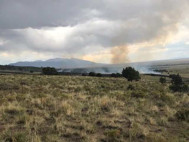
What is a megafire? A megafire burns 100,000 acres or more. In 2008, there were an average of two 100,000-acre fires per year in the USA. In just 14 years, the likelihood of a megafire has increased ten-fold. The Yellowstone National Park fire of 1988 is often given as an example of one of the first megafires. One third of the Park burned. Because that fire burned over a million acres, it was technically a gigafire, also a size of fire becoming more common around the world.
The Hermit Peak Fire in New Mexico is a megafire, having burned 336,638 acres, and is still going. In Colorado, the Hayden Fire of 2002 burned 137,760 acres, and the East Troublesome Fire in Colorado qualifies because it ultimately burned 193,812 acres. Megafires are much much more than acres burned.
Megafires are intense, uncontrollable, travel quickly, and put people, foremostly firefighters, at risk as people are killed, buildings burned, commerce disrupted, air polluted, and animals destroyed. Three billion animals are estimated to have died in the 2020 Australian megafire.
Fires are also starting higher in the mountains. Spring is arriving earlier, and the snow pack melts, leaving plants to dry out. This same trend adds two months to the fire season. Some would now say the fire season is yearound.
Individual wildfires need three circumstances to start. 1) Fuel. Lots of fuel with all the dry wood accumulated over the decades when fires were suppressed as a matter of policy. 2) Oxygen, and 3) a heat source. Tree rings tell us the past few decades are hotter than any time in the past 1000 years. Drought, winds, and dry hot weather equals the potential for an inferno.
Lightening is the primary cause of wildfires. Every degree of warming increases lightening strike numbers 12%. Lightening burns many more acres than human-caused fires. This has something to do with the terrain in which many lightening-caused fires occur. Lightening fires do also cause home fires. Lightening can come through telephone lines and blow up any attached electronics. The fourth factor for fires starting is human behavior. This is where humans cause four out of five of all types of fires.
In the past, older forests with taller trees could tolerate, even thrive, with numerous small fires burning the underbrush. Seedlings grow in the aftermath of small fires; megafires, however, can transform the soil into a glass-like substance. The unhealthy accumulation of undergrowth and tree density, both from the decades of fire suppression, have created a “perfect storm” for mega- and gigafires.
A question: How can you do a controlled burn when conditions for megafires are so prevalent? The Hermit’s Peak Fire, still burning in New Mexico, was a controlled burn started in May during 25mph wind gusts and lower than 10% humidity. The Forest Service acknowledges the risk of trees going up like torches, sending embers up to a mile away. In Colorado in the recent past, there have been prescribed burns that got away from the Nature Conservancy and the Forest Service. The Forest Service, the third week of May, cancelled all controlled burning due to the wildfires started by these efforts. Yet, what other choice is there?
In addition to drought and unfortunate human behaviors, global fires are also increasing due to climate change. Per UCAR, the University Corporation for Atmospheric Research in Boulder, when there is an average 1.1° increase in temperature it creates drier conditions. For every degree of increased warmth, plants need 15% more precipitation to offset loss of moisture.
What does it mean to us that global temperatures have risen 1.1°? First, that 1.1° is not evenly distributed around the globe. The greatest warming is in the Arctic in the cool season. The second is the Earth’s mid-latitudes in the warm season. (Think parts of our planet tilting away from or towards the sun.) Some areas are more than 5° above their norm. One degree equals four times more fires. Unless there is a corresponding increase in precipitation, plants dry out. All those wonderful dry trees in the Baca Chalets, for instance, qualify as fuel for fires.
Air quality & health
You may remember the huge fires in 2020 in Australia. Two fires merged and burned a million and a half acres, over 2,300 square miles. Saguache County is 3,170 sq miles; Alamosa County is 723 sq. miles, to give an idea of size. A study by Ryan, Silver, and Schofield compared air quality over 19 years with air quality during the Australian megafire. There was a 322% increase in particulate matter, PM2.5, tiny particles particularly damaging to the lungs and heart, a 188% increase in carbon monoxide, and a 22% increase in ozone. This led to an estimated 250 deaths and 3,490 hospitalizations from the decline in air quality. Harvard did a study of wildfire smoke and an increase in COVID-19 deaths: “The biggest effects on COVID-19 cases were in the counties of Sonoma, Calif., and Whitman, Wash., with a 65.3% and 71.6% increase in COVID cases, respectively. The biggest effects on COVID-19 deaths were in Calaveras, Calif., and San Bernardino, Calif., with a 52.8% and 65.9% increase, respectively.”
What can be done?
Prevention of wildfires prevents megafires from forming. Mitigation helps prevent fires, and contain the damage from fires which do start. What is mitigation? Removing deadfall, standing dead trees and undergrowth. Planting fire-resistant and drought-resistant plants. Creating a minimum 30-foot swath around homes and other buildings. Following fire restrictions. Trimming low branches. Stacking firewood away from buildings. Throughout summer, in the 30-foot zone, weed whack grasses and rabbit brush, etc. down to the ground.
Restrictions help prevention. East and northeast of Crestone and the Baca lies BLM land. The BLM has enacted a Level 1 fire ban.
Know your evacuation routes and have a pack ready with several days’ supplies in case of fire. Packs need a supply of your medications, food for you and any animals, clothing, water, medications, and important documents. The POA has a map of the evacuation routes out of the Baca. Keep fuel in your vehicles in case of rapid evacuation. Watch out for each other, especially those elderly or disabled, or a parent living alone with small children.
On an evacuation route, if your car stalls or gets stuck, elicit help and get it moved to the side. We have a bottleneck currently to evacuate the Baca and Crestone. One vehicle can trap everyone else. Head to the Moffat School. It is the local Evacuation Center, with showers and a cafeteria. If you cannot get there, look ahead of time for a safe zone. One foot of flame requires ten feet of clear space. A grass fire then needs less safe space than a forest fire. An old maxim applies this summer: “Prepare for the worst and hope for the best.”

