

by Thomas Cleary
photo of Willow Lake and upper valley by Emmy Savage
The upcoming series of summer articles will highlight several outdoor attractions in and around Crestone and the SLV (San Luis Valley). This first article will focus on great hikes up the drainages around Crestone. Most can be done as day hikes but others will require an overnight except for the fittest of us. But before I jump into where to go, I would like to say a bit about how to go. The current backcountry and frontcountry ethics are based around the 7 principles of Leave No Trace:
1. Plan ahead and prepare
2. Travel and camp on durable surfaces
3. Dispose of waste properly
4. Leave what you find
5. Minimize campfire impacts
6. Respect Wildlife
7. Be considerate of other visitors.
Please learn, understand, and follow each of these principles; find out more by going to lnt.org.
Please be careful out there. Know how to read your map, tell someone where you are going, bring extra warm clothes, have plenty of food and water, avoid thunder- storms and lightning, and prepare for the unexpected. Rescue and recovery operations happen all too frequently; I don’t want to get the call and you don’t want the call to be about you.
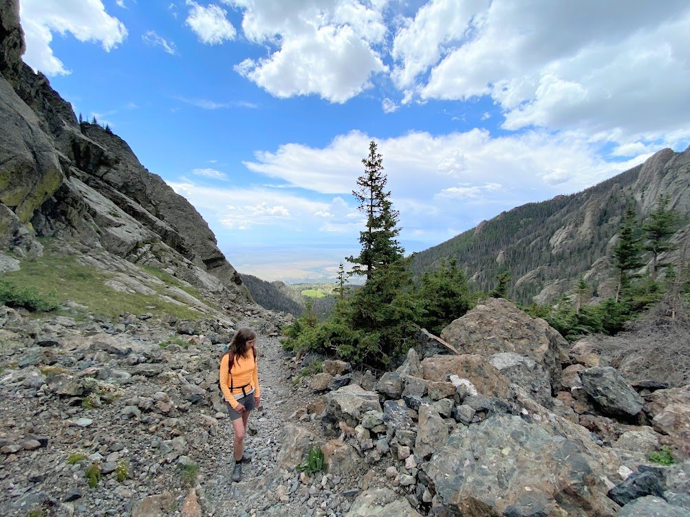
South Crestone Creek
This is a favorite of mine because of the incredible views. To get to the South Crestone/Willow Creek trailhead, take the dirt road heading east from the Crestone Mart (Galena Ave) for about 2 miles, to about 8,800’. The trail follows the alley bottom away from the parking lot for about half a mile to a creek crossing and on to the wilderness boundary beyond. Soon the trail begins to switchback its way up a cool northwest facing conifer for- ested slope, then the trail reenters a grassy southwest facing hillside. As the trail switchbacks up this hillside, the views looking south over the Baca and towards the center of the Valley are startling. The trail crests a ridge about 2 miles and 1,200’ elevation from the trailhead. To reach South Crestone Lake you will continue another 2 miles and 1,500’ elevation.
Leaving the views behind, the trail wanders through a small meadow before rejoining the creek. A bit farther on is another meadow, followed by the next creek crossing. The trail continues up the valley bottom, punctuated by several steep climbs, to a last meadow and the final push up to the lake. This last stretch has warning signs about being washed out a few years ago. The trail has been rebuilt but is steep and loose in places, and is quite a grunt at 12,000’! But when you top out, the lake is suddenly at your feet. If you came to camp, there are some primitive sites on the south side of the lake in the trees. Please treat this fragile treeline environment with the greatest of care. Firewood is particularly scarce, and LNT principles discourage campfires in this setting.
Willow Creek
This is another favorite due to its shorter approach, and amazing views. Trailhead directions are described above. Your first benchmark is Willow Park, about one mile and 1,000’ elevation up the trail. The trail heads out of the parking lot and quickly splits away from the South Crestone Creek trail. During the spring the log bridge over S. Crestone Ck. can be unnerving, but the stream is generally easily forded. Up through a meadow and a series of switchbacks, the trail leads you over the crest of a ridge and then angles slightly down towards Willow Park. There are a few established campsites at the east end of the meadow in the aspen trees.
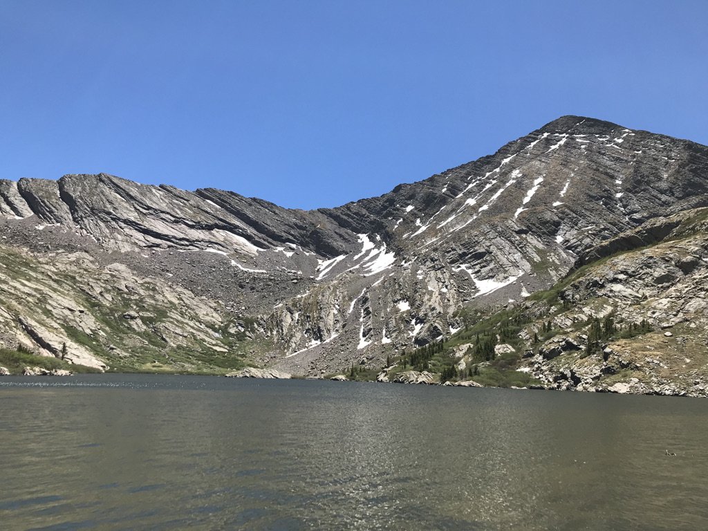
Willow Lake is about 3 miles and 2,000 feet higher. The trail stays on the south facing side of the valley for much of this distance making it a great early season hike that avoids spring snowpack. After lots of switchbacks and crossing the creek below a waterfall, the trail crosses to a northwest facing slope that holds snow, but continue on up to a glacial bench the provides spectacular vis- tas. As you sit and rest taking in the view, look down at the glacial polish and striations left by the last glaciers about 12,000 years ago.
The remaining mile hike to the lake is relatively flat except for the last little push that brings you to the shores. There are some camps in the trees on the south or in the tundra above the waterfall at the far end of the lake, but these are a bit exposed. The same LNT concerns apply here. There is a second lake another mile up valley and peak hikes/climbs on either side.
North Crestone Creek
This trail is a bit longer than those mentioned so far, requiring an overnight at or below the lake for most mortals. Or, ‘basecamp’ at the Three Forks area for access to several diverse hikes and peak/pass climbs. To get to this trailhead go north out of Crestone on Alder St. until it curves east becoming Mica Ave. then turning north again becoming County Rd 71. Follow it until you reach the campground and the trailhead beyond. The two-track, former mining road heads up the valley bottom through beautiful aspen groves. Stay left at the minor fork after about half a mile. Then, after two switchbacks, passing a spring, and a creek crossing, you will reach the trail junction at Three Forks, a total of 2.5 miles and 1,300 feet elevation gain from the trailhead.
The 2 parallel trails to the right go up the Lake Fork and there are a series of nice camps on the lower trail between a quarter and three quarters of a mile. Hiking options from this basecamp include Venable Pass and Peak, Comanche Pass and Peak, and North Crestone Lake, to name a few. North Crestone Lake is another 3+ miles and 2,000’ up the Lake Fork. This northwest facing basin holds snow early season and the final half mile is a steep ‘head-wall’, but the lake and waterfall beyond are worthy rewards. There is more camping at the far end of the lake.
Deadman Creek via Liberty Road
This trail too is a little longer but it is mostly flat and even downhill on the way in. Hike it early in the day to avoid the searing heat and carry plenty of water as there is none available until Deadman Creek. To get to the trailhead, take Camino Baca Grande, turn right onto Camino Real (Two Trees), turn left onto Wagon Wheel, left again onto Camino Del Rey, and follow that back around to the right at the stop sign, rejoining Camino Baca Grande. Go over Cottonwood Creek to the end of the road at a green locked gate. Park and enter with the utmost respect for the nearby resident; camping is not allowed at the trailhead.
After squeezing through the gate the road yields startling views of the southern Sangre de Cristos, the Mount Blanca Massif, and the Great Sand Dunes, 9 miles away. After a half of a mile the road enters the Rio Grande National Forest (RGNF) but continues to parallel the Great Sand Dunes National Park boundary (GSDNP). About three miles from the trailhead (and 500’ elevation loss), you arrive at Deadman Creek.
This is a lovely spot with a wide riparian zone of grasses, flowers and shade trees. Camping is allowed without a permit above the road or in the mountains as it is National Forest land. To camp on the downstream, Park side of the road, a permit is required; call the GS-DNP visitor center for more information on exact boundary locations and permit requirements, 719-378- 6399.
From here it is another 2 miles and about 300’ elevation gain to the Duncan townsite and 1.5 miles and 250’ still further to the Liberty townsite; both are well worth a vis- it. Old unmaintained trails travel up Deadman Creek and Pole Creek above Duncan, accessing much mining history of 100 years ago. Or continue past Liberty for about 10 more miles, joining the Sand Ramp Trail and eventually the Medano Pass Jeep Trail on into the main visitor area of the GSNP. Happy trails! Hope to see you out there!